Our Services
Axis Surveys are specialist Consulting Surveyors to the residential building and development industries. We provide a comprehensive range of Surveying services, with brief descriptions of our most common surveys listed below, so you can order the right survey for your particular job site.
House Set Out
From approved building plans we calculate and setout as many corners of the new structure as required and supply a certificate confirming that the new structure has been set out in the correct position in relation to the property boundaries.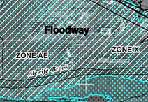
Australian Height Datum (AHD) & Flood Level Plans
AHD is in simple terms, the height of a particular spot above sea level. It can be determined by levelling from known Permanent Survey Marks (PSM’s), or by GPS or GNSS observation. AHD is critical in flood prone or drainage problem areas, or when needing to connect into services such as sewer or stormwater , or when determining “Ground Level” for house design purposes. With a known flood level we can mark the level on the ground or prepare a suitable plan showing the extent of flooding on a site.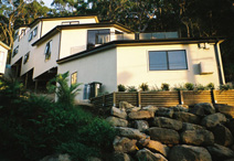
Height Certificates & “Ground Level” Definition
Height Certificates are normally done to confirm the height of floor slabs or roof heights relative to AHD or relative to the Local Council’s definition of “Ground Level”. Determining “Ground Level” is a process that must be undertaken by a Consulting Cadastral Surveyor and should be determined before any design or construction work is commenced as most local authorities have limitations on how high a building can be constructed.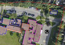
Location Certificate
This service involves locating an existing structure or feature in relation to the property boundaries and preparing and certifying a suitable plan to accompany the location certificate.
Building & Civil Construction Setout
Both these types of surveys are carried out on a larger scale than a house setout, and involves setting up survey control and often make use of gridlines, and require ongoing interaction with qualified technical staff, before and during the project. We have specific staff to look after these more demanding jobs and they would normally be your one point of contact for the life of the project.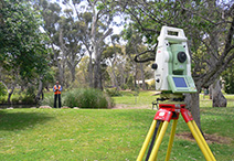
Contour and Detail Surveys
Give a true representation of the shape, features and services of a site. They normally include manmade improvements, trees and natural features, and if required adjoining property information. Most development sites require more information than a typical house site for Designers and Architects to design new structures on, and normally will need additional information in relation to adjoining buildings, services etc. “Ground Level” assessment by a Consulting Cadastral Surveyor will normally be required to ensure compliance with building height requirements on a particular site.
Boundary Survey Work
Remarking or offsetting of existing property boundaries in QLD requires by law that a formal Identification Survey Plan of the survey work undertaken be prepared and lodged with the Dept of Natural Resources & Mines. Identification Surveys are more common in older areas and when building on or near the boundaries, with cost depending on the age of the property, the size, the location and the characteristics of a particular site and also its proximity to more recent survey work. An Identification Survey of a future Development site is recommended before design work commences to ensure there are no discrepancies with boundary dimensions, or encroachments that need to be dealt with, particularly in older areas or if building on or near a boundary
Project Feasibility
Axis Surveys and our proven team of consultants can undertake an assessment or property investigation on a particular site, either before or after you purchase it. We can identify site constraints and opportunities and prepare an evaluation of the suitability of the site for your intended use, including costings and expected timeframes. We can assist you to find the right property by identifying potential problems before you start.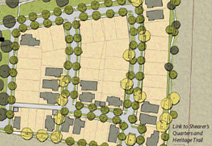
Reconfiguration of Existing Lots or Subdivisions
Axis Surveys has a wealth of experience in following small to medium subdivisions through from concept to completion within most Councils in South East Queensland. Subdivisions can be complex with nearly every site different, and we want you to be able to benefit from our experience with subdivisions to do what we can to help you avoid the many problems we have seen over the years.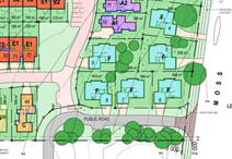
Building Unit & Community Title Developments
Axis Surveys offers a wide range of professional services in relation to many different types of community title subdivisions, (formerly known as Strata and Group Title developments). To subdivide a building into separate titles from a simple duplex up to a multi storey large development is most commonly done using a “Building Unit Plan”, however “Volumetric” or even “Standard Format Plans” can also be used to advantage and in certain situations small unit developments can be achieved without the need to use a Body Corporate. Contact us to discuss your particular project and what options may be available to you for titling.
Height Certification
Most local authorities in SE Qld have limitations on how high structures can be built above “Natural Ground Level”. Assessing NGL is not always straightforward, and it is essential that a Consulting Surveyor determine NGL on your site before any design or construction work commences. Before your designer or Architect sets the floor or roof heights, contact us to get it right before you start.
Project Assistance
We offer a wide range of assistance to you with your development project, and can give you as little or as much assistance as you need. We can assist with council prelodgment meetings, development applications, arranging and managing other consultants or contractors. Axis Surveys is now an accredited SealSMART Consultant for the Brisbane City Council, which is a new innovation to reduce the time taken for survey plans to be approved by the BCC, once all conditions have been complied with.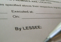
Leases
We have a wealth of experience in preparing many different types of leases from small sub-leases to major shopping centres. Most leases require connection into the boundaries, with individual office or shop leases or whole floor leases being the most common. A lease of land requires the preparation of a formal survey plan, and often requires the consent of the local authority. Contact us to discuss your leasing needs, to make sure you get the right lease for your purposes.
Easement and Covenant Surveys
An easement or a covenant is an area of land that generally covers only part of a lot and is registered on the title. In most cases they restrict what can and can’t be done over that part of a lot. Most common easements are for access to or from new or existing lots, or for services or for drainage. Covenants are more likely to be used for environmental purposes involving local or state government. Contact us for assistance with easements or covenants, and assistance in arranging for the legal documents to be prepared by a legal practitioner.
Encroachments & Boundary Dispute Resolution
The existence and the extent of an encroachment on or by a particular property normally requires that an identification or part identification survey be undertaken to re-establish the property boundary or boundaries, and to show any encroachments (should any exist). The bulk of disputes between neighbours is usually over the location of a fence, retaining wall, structure, gutter line, building, tree etc, and this can usually be resolved by the undertaking of an identification survey that will show structures on or near the boundary in relation to the actual boundary. Axis Surveys has been involved in numerous disputes between neighbours and do our best to assist both neighbours to fully appreciate the issues at hand and to do what can be done to avoid litigation. Should litigation become the only way to resolve a dispute between neighbours, we are happy to assist our clients through this process as painlessly as possible. Please contact us on 33638100, for a quotation or more advice in relation to your particular situation.
Unit or Town House Developments
Axis Surveys provides a wide range of services in relation to Community Title subdivisions and in certain situations subdivision can occur without the need for a body corporate. To subdivide a lot to create separate titles within a building or to subdivide units within a building is normally achieved through a Building Format Survey, which would typically include duplex or triplex developments and multi storey buildings, and is commonly referred to as “Strata Titling’”. Town House developments of one or more storeys can be titled using a Standard Format Plan, which in simple terms is a subdivision of land, and in the past was known as a “Group Title” development. Please contact us on 33638100, for a quotation or more advice in relation to your particular situationReady to Order?
To order any of our services, or to make an enquiry, please call us or send an email.
 Send an email